In an increasingly data-driven world, location intelligence has become vital for smarter, faster, and more informed decisions. Whether you're involved in urban development, infrastructure planning, environmental monitoring, or asset management, GIS Mapping (Geographic Information System Mapping) is transforming how organizations understand and interact with the physical world.
But what exactly is GIS Mapping—and why should your business invest in it? Let’s explore the benefits and impact of GIS technology, particularly when combined with UAV and remote sensing.
GIS provides actionable insights by combining geographic data with business information. Real estate developers can identify optimal land parcels, municipalities can track infrastructure needs, and logistics teams can optimize routing with greater accuracy.
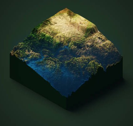
UAV-based GIS solutions generate highly accurate orthomosaic maps, 3D terrain models, and digital elevation data. These outputs enable better infrastructure design, environmental assessments, and urban planning—reducing costly errors.
Large-scale surveys can now be completed in hours instead of weeks, thanks to UAVs. This is essential for projects under tight timelines, such as Saudi Arabia’s Vision 2030 initiatives or infrastructure growth across the GCC.
UAVs can safely survey rugged mountains, coastal areas, and remote deserts, minimizing risks to human crews while delivering reliable data in hard-to-reach locations.
GIS Mapping reduces the need for excessive manpower and field equipment. It’s a scalable, eco-friendly solution that delivers long-term value for your business and the environment.
From tracking construction progress to monitoring environmental changes, GIS allows near real-time data visualization. You can make decisions based on current and accurate geospatial information.
“GIS Mapping isn’t just a digital transformation tool—it’s the cornerstone of smarter infrastructure, planning, and sustainability in the Gulf region.”
At GISMappers, we combine cutting-edge UAV, GIS, and AI technologies to deliver precise and efficient land survey solutions across Saudi Arabia, UAE, Oman, and beyond. From smart city design to environmental and coastal studies, our services are tailored to your industry’s unique needs. Contact us today to discover how GIS Mapping can benefit your next project.
© Copyright 2025. All Rights Reserved by GISMappers Saudi Arabia