GIS Mappers was commissioned by DAMAC to perform a comprehensive quay wall and berth survey as part of the Port Sultan Qaboos Development Project in Muttrah, Muscat, Oman. This project is a landmark urban redevelopment initiative that aims to transform over 114 hectares of the former commercial port into a vibrant mixed-use waterfront destination. With a proposed Gross Floor Area of over 700,000 square meters, the project required critical marine infrastructure assessments to support planning, design, and execution phases.
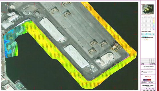
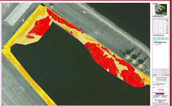
The focus of the survey was to provide detailed structural data for berths 1 through 10, including bathymetric mapping of the seabed, inspection of quay wall conditions, and foundational assessments below the waterline. GIS Mappers deployed advanced hydrographic equipment, including the TSS DMS 3-05 dynamic motion sensor, AML sound velocity profilers, and M3 Multibeam Sonar, integrated with Hypack and Hysweep software for seamless data acquisition and processing. A Leica RTK GNSS system and Hemisphere DGPS were used to ensure sub-centimeter horizontal and vertical positioning accuracy.
Pre-survey investigations were conducted to assess access, safety, and environmental conditions around the designated berth areas. A Valeport Tide Master tide recorder was installed on-site to ensure reliable tide correction throughout the operation. The GPS antenna and sonar transducer were precisely aligned on the same vertical axis to reduce measurement drift and distortion. Daily bar checks and CTD (Conductivity, Temperature, Depth) dips ensured accurate sound velocity profiles were collected to support bathymetric depth calibration.
During acquisition, all multibeam sonar data was collected along carefully plotted tracklines to ensure full coverage of the quay structures and berth areas. Vessel motion was actively corrected in real-time using heave, pitch, and roll data from the motion sensor. Raw bathymetric data were processed and validated using Hysweep, with corrections applied for draft, tide, and sound speed. Final deliverables included high-resolution digital seabed models, quay wall structural profiles, XYZ point clouds, and integrated reports georeferenced to the local UTM coordinate system.
The Port Sultan Qaboos survey provided DAMAC with actionable insights into the current condition of underwater infrastructure and allowed for accurate modeling of quay wall integrity and seabed topography. These results are being used to inform design decisions for the new marina, waterfront promenade, and commercial spaces envisioned as part of the development.
GIS Mappers is proud to support iconic infrastructure projects across Oman and the wider GCC, offering precision hydrographic and bathymetric surveying services that meet international standards. This project further highlights our capabilities in supporting large-scale urban coastal developments through reliable marine data acquisition and geospatial engineering expertise.
© Copyright 2025. All Rights Reserved by GISMappers Saudi Arabia